Distance
11.29 km
Elevation gain
489 m
Route type
out-and-back
Difficulty
Moderate
Peaks on this trail
About this trail#
Deep in the wilderness of the Kudremukh range, the trail to Kurinjal Peak is a beautiful mix of adventure and changing landscapes. The trek begins along rocky forest paths before reaching the Bhadra River, with river crossings and a rustic bridge adding to the experience. Beyond the river, the trail winds through dense, mist-covered forests, surrounded by the lush greenery and quiet wilderness of the Western Ghats. As the forest gradually opens up, the trail becomes steeper and more challenging, leading into the final ascent towards the peak. The climb rewards you with sweeping views of the rolling hills and valleys of the Kudremukh range, often wrapped in clouds and mist. With its combination of river crossings, bridges, forests, mist, and a demanding summit climb, the Kurinjal trail offers a compact yet immersive Western Ghats trekking experience.
ContributorsVVallabh Deshpande
Trail Information#
Forest Path to the Bhadra River
The trail begins on a rocky forest path that descends from the trailhead through mixed woodland. The path narrows through undergrowth and is slippery on steeper sections after rain. Fallen trees occasionally block the route at low points. The river comes into view where the canopy opens.
Bhadra River Crossing
A wooden bridge and a ford both cross the Bhadra at this point. The ford can run strong after heavy monsoon rain; assess conditions on arrival. This is the lowest point of the route.
Shola Forest
Past the river, the trail climbs through dense shola forest. The canopy closes overhead and the temperature drops noticeably. The trail is not always clearly defined through this section; follow the slope upward and stay within the tree cover. Leech density is highest here during the monsoon (June–September). A microwave tower and an associated building at the upper edge of the forest mark the end of the shola section and serve as the main navigation reference on the climb.
Grassland Ridge
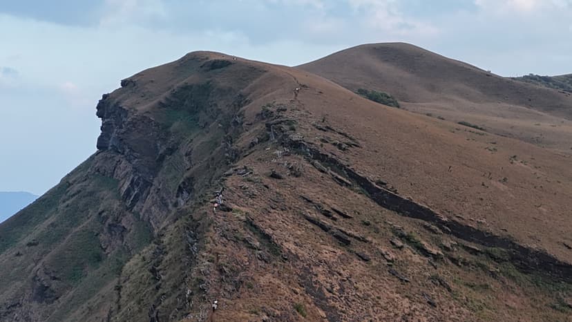
Above the forest, the trail opens onto open grassland. The route follows the ridge toward the summit block, which is visible ahead on clear days. The terrain is exposed; in mist or cloud, keep to the ridge line rather than traversing into the grass. This section gains elevation gradually over the longest horizontal stretch of the route.
Summit
The final section is a steep climb over exposed rock. The rock is slippery when wet. The summit is a defined rocky point with no shade or shelter. In clear conditions, the view extends across the rolling hills and valleys of the Kudremukh range; cloud and mist frequently move in from the west and can obscure the view within minutes of arriving.
Getting there#
Trail route
Route flyby#
Preview the terrain before you go — a 3D fly-through of the full route.
GPX file#
Download the GPX route to use with your GPS device or hiking app. Learn how to use GPX files. To protect our trail data from bulk harvesting, downloads are limited to one per account per week.
🗺️
Sign in to download
Create a free account to download the GPX file and use it with your GPS device or hiking app.
Trail reports#
Trail conditions and experiences shared by hikers who've done this route


Wildlife & Nature#
Leeches are active through the shola forest section and around the Bhadra River crossing throughout the monsoon (June–September). Kudremukh National Park is documented habitat for lion-tailed macaques and Malabar giant squirrels, though sightings from this specific route are unconfirmed in available reports.
Camping#
No camping allowed!