Distance
6.86 km
Elevation gain
525 m
Route type
out-and-back
Peaks on this trail
About this trail#
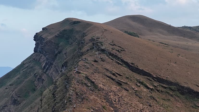
Gangadikallu is a 1,465-metre summit in Kudremukh National Park, reached by a shola forest trail with a steep zigzag final climb to an open ridge. The trailhead sits at a forest checkpost roughly 8 kilometres from the Kudremukh Forest Office, where permits are verified and guides assigned before entry. The route begins on a wide jeep track under closed shola canopy. After roughly 2 kilometres the track gives way to a footpath that alternates between shola patches and open grassland as the gradient increases. The upper section is the steepest: a series of tight zigzags over loose, iron-rich gravel leads to the summit ridge. A metal communication tower marks the highest point. From the ridge, the Lakya Dam backwaters are visible to the southwest. Kudremukh peak, Kurinjal, Valikunja, and the Kyatanmakki Hills form the broader horizon. On clear days, the abandoned Kudremukh iron ore mining town is visible in the valley below. The ridge extends beyond the tower, allowing further walking along the open crest before the return. The park enforces a strict no-waste policy throughout. There are no water sources on the trail and no facilities at the trailhead or along the route. Leeches are active during the monsoon and into October.
Trail Information#
Jeep Track to Shola Entry
The trail begins at the forest checkpost on a wide jeep track of packed earth, initially flat, with a gradual incline starting after the first few hundred metres. The shola canopy is closed overhead, dense enough to block most direct light. There are no forks; the jeep track is the route. This section runs for roughly 2 kilometres.
Shola and Grassland Ascent
Past the initial forest section the track narrows to a footpath and the terrain begins to open. The route alternates between shola patches and open grassland as the elevation increases steadily. The grassland sections give clear sightlines to the ridges to the south and west. The gradient becomes noticeably steeper in the upper part of this section.
Zigzag Climb
The final kilometre involves a series of tight zigzags over loose, iron-rich gravel. The surface shifts underfoot, particularly on the descent, which requires slow and deliberate footing. Exposure increases as the trail nears the ridge. A brief flat shoulder partway up precedes the last push to the top.
Summit Ridge
The ridge opens onto open grassland. A metal communication tower marks the highest point at 1,465 m. The ridge continues beyond the tower, allowing further walking along the crest before the return. From here: Lakya Dam backwaters to the southwest, Kudremukh peak, Kurinjal, Valikunja, and the Kyatanmakki Hills across the horizon. On clear days the abandoned Kudremukh iron ore mining town is visible in the valley below.
Getting there#
Trail route
Route flyby#
Preview the terrain before you go — a 3D fly-through of the full route.
Trail reports#
Trail conditions and experiences shared by hikers who've done this route

GPX file#
Download the GPX route to use with your GPS device or hiking app. Learn how to use GPX files. To protect our trail data from bulk harvesting, downloads are limited to one per account per week.
🗺️
Sign in to download
Create a free account to download the GPX file and use it with your GPS device or hiking app.
Wildlife & Nature#
Malabar giant squirrels are regularly reported along the trail. Common langurs are frequently seen in the shola canopy sections. Sambar deer and gaur are occasionally sighted in the grassland stretches. Malabar Pit Vipers are present; watch underfoot in leaf litter. Leeches are active on the trail from June through October.